The issue of naming in Haiti and the recognition or non-recognition of that name is something that I’ve been thinking about for a few years now. David Geggus wrote a great chapter called “The Naming of Haiti” in his book Haitian Revolutionary Studies. While undertaking my dissertation research, I was struck by the continued use of “Saint-Domingue” or “St. Domingo” by foreigners when they were referring to the territory that Jean-Jacques Dessalines and his generals had renamed “Hayti.” I wrote a short piece in the French journal Riveneuve Continents called “Identif[ying] the Island in its new situation”: The struggle for Hayti to overcome St. Domingo.” In this article I argued “Not only did the name ‘Hayti’ represent a break from France and a return to a time before colonialism, but the people assumed the roles of the rightful residents of the island. Natives; the land was theirs.” While I was a fellow at the John Carter Brown Library in 2013, I gave a talk and used map titles to illustrate the point that I was making about the uncertainty about Haiti’s status after 1804 and the resistance to fully recognize Haiti’s independence. The map titles that I studied suggest that international mapmakers were slow to adopt “Haiti” or “Hayti” as the name for the territory and only began to do so around the time that France officially recognized Haitian independence (1825). Even then, however, many maps continued to use the colonial name in addition to the new name.
I collected all of the maps published between 1804 and 1900 that reference the island of Hispaniola on CaribMap: A Cartographic History of Caribbean Islands and noted what they called the island or the western side of the island (I removed a few that didn’t seem to have matching maps and captions). This is simply a sample and I think it would be worthwhile to do a comprehensive study of all maps available! Here are the titles that I analyzed: Table of Map Titles.
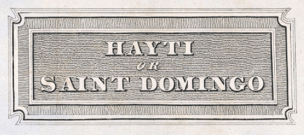
Of the 26 maps, 10 exclusively used “Saint-Domingue,” “St. Domingo,” or “Santo Domingo”; 10 used both a translation of “Saint-Domingue” and “Hayti” or “Haiti”; and 6 exclusively used “Hayti” or “Haiti.” The number for the exclusively “Saint-Domingue” titles is slightly skewed since one mapmaker and publisher issued two new editions of an 1811 atlas and another mapmaker issued two maps the same year–one of the entire island and one of just the western side.
The bulk of the 10 “Saint-Domingue” maps were published prior to 1825, the year that France recognized Haitian independence. Only one “Saint-Domingue or Haiti” map was published before 1823 (in 1815) and the first exclusively “Haiti” map was not published until 1871. I find it really interesting that even after France recognized Haiti’s independence, mapmakers continued to use two names for the territory; between 1825 and 1871, maps either labeled the territory “Saint-Domingue” or “Saint-Domingue or Haiti.” The United States was the last country to recognize Haiti’s independence (1862) and it is remarkable that even though all Atlantic nations had extended diplomatic recognition to Haiti, it was another decade before this recognition was articulated on a map.
Has anyone found other maps that don’t follow these trends?
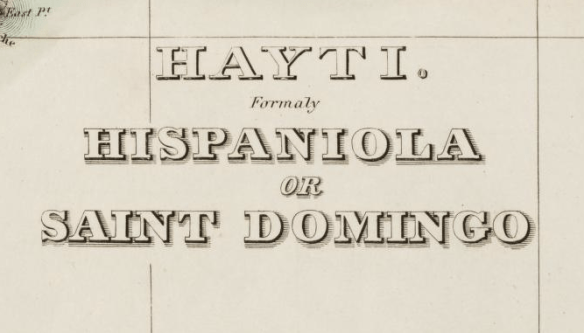
Mitch Fraas commented below and included a link to this map in the University of Florida Library collection. The map, from 1822, is titled “Hayti, Formerly Hispaniola or Saint Domingo.” Interestingly, the same mapmaker (Fielding Lucas) and publisher (Carey & Lea) produced another map the same year with the title “Map of Hispaniola, Or St Domingo.” The next year, Lucas created another map titled “Hayti or Saint Domingo.”
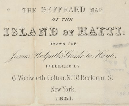
Mitch also found a map from 1861 in the Harvard Library collection titled “The Geffrard Map of the Island of Haiti,” published in New York. This map was published one year before official US recognition of Haiti.
My diplomatic, legal, and economic sources (particularly in the case of the British), in contrast, begin using “Hayti” or “Haiti” in the early 1810s, despite the fact that no foreign power had officially recognized the country’s independence. This difference, I suspect, has to do with proximity to and contact with Haiti. Merchants almost immediately began calling the territory Hayti. The admirals from the Jamaica station who patrolled the waters around Haiti began calling the territory Hayti around 1810. By about the 1820s, most British officials were using “Hayti” rather than “St. Domingo.”
I’m curious why mapmakers were so resistant to the change of name; is this unusual? I am certainly not an expert on maps and would be grateful for any comments and observations!

This is fantastic! I suspect for the early post-Independence maps that old plates are just being recycled given how expensive map making was. But really it goes on much too long for that to be the only factor. Just looking through the Florida collection I see a few oddballs – like this from 1822 naming Hayti as “formerly St. Domingo” http://ufdc.ufl.edu/UF00004620/00001/citation I would be curious how early the US pro-emmigration to Haiti folks started using the name. Certainly by the 1860s: http://ids.lib.harvard.edu/ids/view/30615453?buttons=y . I was also surprised to see Hayti used in some of Bellin’s 18th c. maps e.g. http://ufdc.ufl.edu/UF00005027/00001/citation
That 1822 map from Florida is super interesting because Fielding Lucas made another map the same year (also published by Carey & Lea) with the title “Map of Hispaniola, Or St Domingo.” I will add the image of the one from the Florida collection to the post; nice find!
I also wonder about US pro-emmigration to Haiti materials would refer to Haiti since that began in the 1820s. That map from Harvard is great (and pre-American recognition)–I’ll add it too.
Another great study would be of pre-independence labels (less politically charged, I think)–I’d seen “Hayti” or “Ayiti” used on maps from the 17th century, but I hadn’t realized that it continued in the 18th century. Perhaps the continued presence of the former name helped inspire the re-naming!
Thanks for your comments and additional links!
James Redpath is an interesting guy. He was President Geffrard’s agent in the US, in charge of promoting black emigration to Haiti–his Guide to Hayti was undoubtedly part of the campaign. He was a journalist and publisher and for a time took over one of the prominent abolitionist journals, The Pine and Palm.